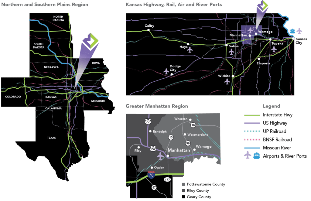
Transportation Infrastructure in and Around Pottawatomie County, KS
Located centrally in the country, Pottawatomie County is not isolated. Instead, we’re connected to surrounding regions through well-developed and maintained transport systems. Our county is connected with U.S. Route 24, Interstate 70, and Union Pacific Railroads. We also have easy access to the Manhattan Regional Airport and the Kansas City International airport. In terms of proximity to larger urban areas and markets, we’re near Omaha, NE, Wichita, KS, and Kansas City, KS/MO.
With excellent transportation infrastructure in place, Pottawatomie County, KS, provides advantageous regional and national connectivity for businesses. Our location is beneficial for both personal/professional travel, and transportation of commercial and industrial goods. To learn more, find a business site or location in Pottawatomie County, or contact us.
Air Service
With numerous regional and local airports in proximity, Pottawatomie County can be an easy destination or departure point for heading to/from anywhere in the country. Although other airports are also within proximity (including the Salina Regional Airport, Johnson County Executive Airport, and more), the Manhattan Regional Airport and the Kansas City International Airport are considered the major air transport options for those in and around Pottawatomie County.
The Manhattan Regional Airport
The newest terminal serving the Flint Hills Region, the Manhattan Regional Airport provides commercial and general aviation services. The airport offers flights from American Eagle, the regional affiliate of American Airlines, and flights offered include daily regional jet service to Dallas/Fort Worth (DFW). In addition, the airport offers car rental services and vending machines for convenience.
Kansas City International Airport
Accommodating over ten airlines, the Kansas City International Airport offers transportation to major domestic airports and select international destinations. From Wamego, the airport is generally less than a two-hour drive, making access to the airport relatively simple for those across Pottawatomie County.
Highway Systems
Pottawatomie County lies along a number of important roadways. Interstate 70 connects the county to a number of states and urban areas, while multiple state highways provide great regional connectivity.
Interstate 70
Perhaps the most important and well-known road in this area is Interstate 70. Founded in 1956, this major highway runs from Utah to Maryland. It passes many urban centers such as Denver, Kansas City, and Indianapolis. Route 99, which runs through the middle of the county, links to the interstate.
Kansas Highway 16
This state route runs through the northern section of Pottawatomie County. On its western end, it connects to U.S. Route 77, which can take you to Lincoln, Nebraska. Its eastern end connects to U.S. Route 40, which goes to Kansas City.
Kansas Highway 99
This state route runs through the middle of the county and connects to Interstate 70. To the south, it runs through Emporia, Kansas and even extends into a nearby area of Oklahoma City.
Kansas Highway 24
This historic U.S. route goes from Central Colorado to Michigan. Heading east on this famous highway, you can pass through Topeka and Kansas City.
Kansas Highway 63
This state route runs through the eastern section of our county and connects to Route 24 in St. Marys.
Distance from Major Markets
Since we’re centrally located, Kansas and Pottawatomie County are situated near various major markets in surrounding states. The following chart shows the distance between Wamego, KS, and major markets in the region:
|
City |
Miles |
|
Topeka |
43 |
|
Kansas City |
107 |
|
Lincoln |
135 |
|
Wichita |
151 |
|
Omaha |
163 |
|
Tulsa |
258 |
|
Des Moines |
300 |
|
Oklahoma City |
312 |
|
Saint Louis |
354 |
|
Denver |
514 |
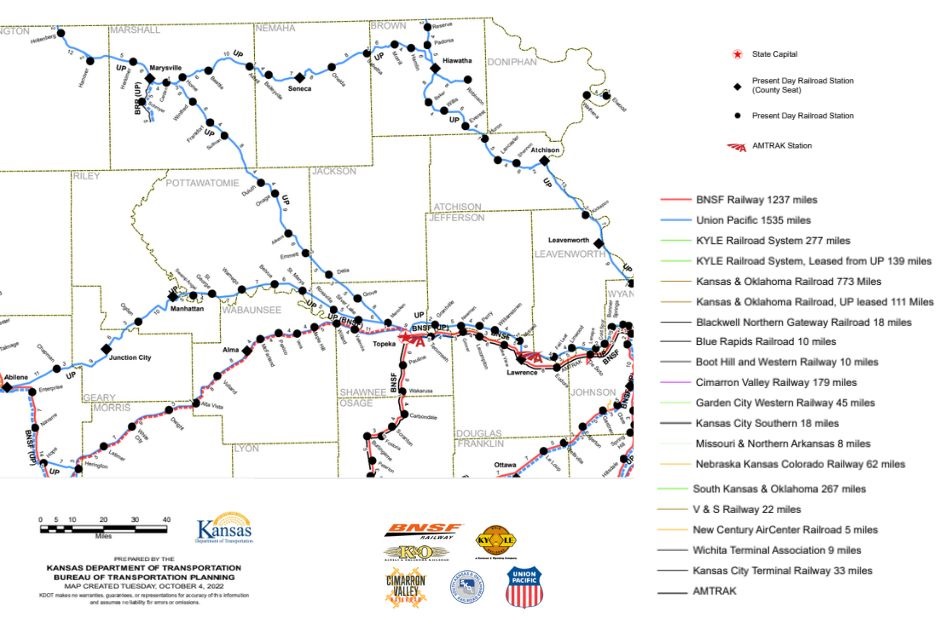
Rail Service
The following excerpt of the KDOT Kansas Railroad Map shows rail lines in Pottawtomie county and the surrounding area:
Shipping and Distribution
There are two cooperatives that currently operate within Pottawatomie County. These cooperatives also have multiple locations.
Ag Partners Cooperative
Ag Partners Cooperative
201 North 6th St.,
PO Box 204, Seneca, KS 66538
877.336.6153
contact@agpartnerscoop.com
Locations:
- Wamego (farm supply, feed, grain, seed) – 200 East Valley Street, Wamego, KS 66547, 785.456.9600
- Belvue (agronomy, grain) – 305 Noble Avenue, PO Box 147, Belvue, KS 66407, 785.456.9190
- St. Marys (agronomy, farm supply, feed, fuel, grain, NH3, propane) – 717 West Bertrand, St. Marys, KS 66536, 785.437.2984
Mid Kansas Cooperative
Mid Kansas Cooperative
PO Box D,
Moundridge KS 67107
800.864.4428,
ngouldie@mkcoop.com
Locations:
- Onaga (24 hr. Fuel, agronomy, feed, feed mill, grain) – 401 Oak, Onaga, KS 66521, 785.889.4226
- Westmoreland (24 hr. fuel, anhydrous, feed, service station) – 203 S Hwy 99, Westmoreland, KS 66549, 785.457.3671
- Manhattan (24 hr. fuel, agronomy, feed mill, grain) – 384 Excel Road, Manhattan, KS 66502, 785.776.9467
Traffic Counts
The Kansas Department of Transportation (KDOT) provides traffic count maps for the state, including in and around Pottawatomie County. The excerpt map below shows relevant traffic counts from KDOT’s 2022 State Traffic Maps:
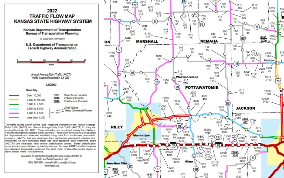
The table below displays pertinent traffic counts from the 2020 KDOT map, as well as the estimated traffic counts for 2040, as estimated by the Flint Hills Metropolitan Planning Organization (Flint Hills MPO).
|
Location |
KDOT 2020 Count Map |
MPO 2040* |
|
US-24 at McCall |
27,900 |
33,283 |
|
US-24 near Flush |
12,500 |
17,035 |
|
US-24 near Columbian |
11,600 |
13,209 |
|
US-24 east of K-99 ~2 miles |
4,670 |
5,390 |
|
K-99 north of US-24 |
3,340 |
4,383 |
|
K-99 south of river |
3,810 |
6,857 |